


New nations seem to pop up with alarming regularity. At the start of the 20th century, there were only a few dozen independent sovereign states on the planet; today, there are nearly 200!
Get Started for FREE
Sign up with Facebook Sign up with X
I don't have a Facebook or a X account


 Your new post is loading...
 Your new post is loading...
Your new post is loading...
New nations seem to pop up with alarming regularity. At the start of the 20th century, there were only a few dozen independent sovereign states on the planet; today, there are nearly 200! 

Ok...So this is neat... Only thing is you must SIGN IN with a social media account or SIGN UP. ... It is free. Cool way to create a visual, moving timeline. For the moment I might use this more in HIstory,but the door is completely open!
On myHistro you can create advanced geolocated timelines that you can play as presentations. Pin your events, videos and photos to the map and share them with friends and family.
This new resource, myHistro, combines interactive maps with timelines to organize stories, journeys or historical events as the move over time and place. By embedding photos, videos and links this creates an incredibly dynamic platform for telling historical and geographic stories. By combining these features, this is a powerful tool to create customized resources for you students. Pictured above is a sample timeline that shows the spatial and temporal journey of the Olympic torch for the 2012 Games.

benjamin costello's curator insight,
May 20, 2015 5:38 PM
Interesting concept but not totally fleshed out for use by historians... genealogists perhaps would have a better or easier time using this program. It is very interesting but it only allows for one movement, so rather than showing the history of a nation you can show the history of a family through its interactive timelines. Google maps is not always accurate as well.
Great visual for kids ( and adults) learning about climate change and what we are doing to continue global warming. "Animated time-lapse video of anthropogenic carbon dioxide emissions in map form, spanning the 18th century until this current first decade of the 21st centur...
This is not a complete data set, but the video still shows the striking connection between CO2 emissions and the historical geography of industrialization."
|
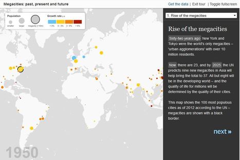
By 2025, the developing world will be home to 29 megacities.
Through this interactive mapping feature with rich call-out boxes, the reader can explore the latest UN estimates and forecasts on the growth of megacities (urban areas with over 10 million residents). These 'cities on steroids' have been growing tremendously since the 1950s and present a unique set of geographic challenges and opportunities for their residents.
Tags: urban, megacities.

Tori Denney's curator insight,
May 27, 2015 3:36 PM
World cities and megacities - Presently , the mega cities of the world have to have a population of at least 10,000. Many cities are very near the minimum to be considered a mega city, but are not quite there. By 2025, the developing world, as we understand it now, is estimated to be home to 29 megacities.
So there are a few missing...but still a fun interactive resource for teachers and kids.
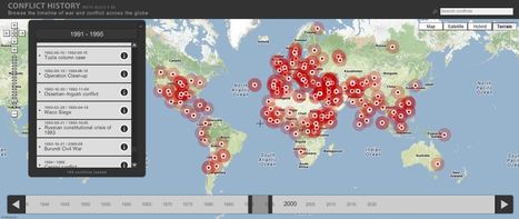
Browse the timeline of war and conflict across the globe.
This database of global wars and conflicts is searchable through space and time. You can drag and click the both the map and timeline to locate particular battles and wars, and then read more information about that conflict. This resource would be a great one to show students and let them explore to find what they see as interesting. This site is brimming with potential.

olsen jay nelson's comment,
August 16, 2012 7:46 AM
This is just what I've been looking for, believe it or not:-)

Paul Rymsza's comment,
August 22, 2012 2:15 PM
the potential of this site is amazing between the interactive learning system and the correlation between the timeline and location. If the human geography class is anything like this i can't wait for it!
|


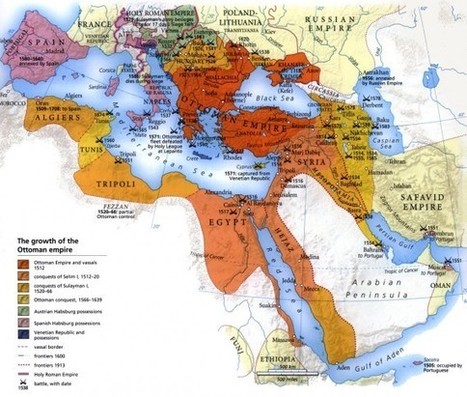
Amazing to see many of the countries and empires that are no longer around. Also with the dissoution of many of the empires it lead's to many of the issues that were are dealiing with today. Splitting the Austro-Hugaraian Empire after WWI along ethnic lines didn't really work and helped to lead to WWII. The Germans in the Sudetenland in Czechoslovakia fro example. See http://en.wikipedia.org/wiki/File:Sudetendeutsche_gebiete.svg
for the area of German population.
10 countries that have become nonexistent in the 20th century include Tibet, East Germany and Yugoslavia. These countries have died off because of ethic, religious and cultural falls that were quickly taken over by bigger and more powerful countries.
Essentially this article boils down to the issues of religion, ethnicity and nationalism. People who are diverse and have different ideas generally cannot all live together under one rule and agree on everything, hence nations split and new ones form to cater to their own beliefs and similarities.