|
Rescooped by Yves Carmeille "Libre passeur" from iGeneration - 21st Century Education (Pedagogy & Digital Innovation) |


No comment yet.
Sign up to comment
Get Started for FREE
Sign up with Facebook Sign up with X
I don't have a Facebook or a X account


 Your new post is loading...
 Your new post is loading...
Your new post is loading...
No comment yet.
Sign up to comment
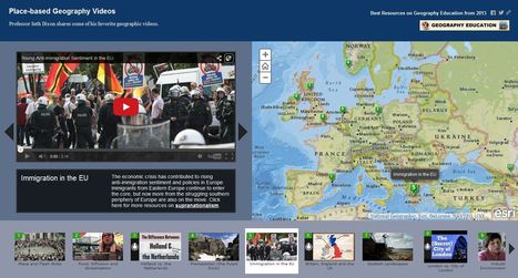
Professor Seth Dixon shares over 50 of his favorite geography videos in this online map http://bit.ly/KDY6C2

Melissa Marie Falco-Dargitz's curator insight,
November 3, 2014 12:02 PM
It was nice to see where everything was happening. I hope it gets updated to more current events. I wish we had something like this when we were looking at the invasion of Kuwait. 
Caroline Ivy's curator insight,
March 15, 2015 5:19 PM
Seth Dixon uses ArgGIS to juxtapose maps with the location a video is associated with.
This idea has crossed my mind before. Now, a video can be contemplated with the spatial accuracy needed. This connects events to a place, and can help students more fully grasp the geospatial distribution of events. 
Nita Ardi's curator insight,
January 14, 2019 12:16 PM
Great resource for classroom and information to get kids going.
|

Since 1996, the Rumsey collection’s online database has been open to all, currently offering anyone with an internet connection access to 67,000 maps from all over the globe, spanning five centuries of cartography. Via Tom D'Amico (@TDOttawa)
|